Cast Off Confidently:
– Stay on course, and track more adventures with these rugged, floating handhelds.
Features:
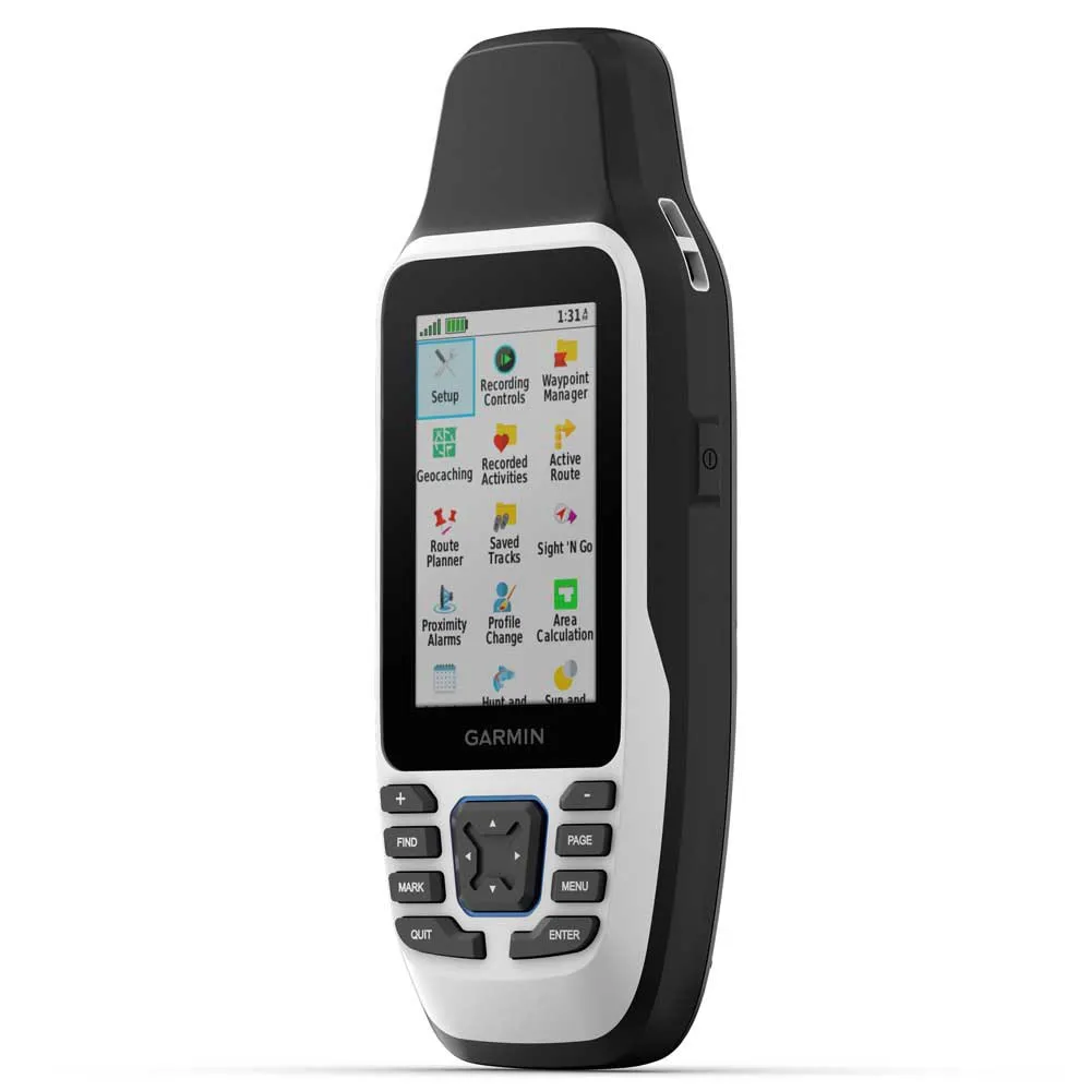
– It’s water-resistant, it floats, and it’s fogproof, so it belongs on the water — just like you.
– This thing can remember up to 10,000 waypoints and more, so you don’t have to.
– It’s nice to have reliable positioning when you’re out on the water.
– The built-in compass will point you in the right direction.
– Get the best of Garmin and Navionics data with optional BlueChartg3 coastal charts.
– Stay out longer with up to 19 hours of battery life in GPS mode.
Rugged Handheld:
– This handheld is water-resistant (IPX7) with a high-resolution color display you can read in the sun. The glass is even scratch-resistant and fogproof.
Designed To Float:
– If rough waters come and the handheld goes overboard, don’t worry. This device floats.
Battery Life:
– User-replaceable AA batteries (not included) provide up to 19 hours of battery life in GPS tracking mode.
Accurate Tracking:
– With support for multiple satellite constellations — such as GPS, GLONASS, Beidou, Galileo, QZSS and SBAS — you’ll get accurate, reliable tracking and positioning around the world.
Increased Memory:
– More memory than previous models means you can save and track 10,000 waypoints, 250 routes and 300 fitness activity files.
Built-In Compass:
– The 3-axis tilt-compensated electronic compass shows your heading — even while the boat is standing still.
Specifications:
General:
– Physical Dimensions: 2.67´´ X 6.85´´ X 1.67´´ (6.77 X 17.40 X 4.23 Cm)
– Display Size: 1.5´´W X 2.5´´H (3.8 X 6.3 Cm); 3´´ Diag (7.6 Cm)
– Display Resolution: 240 X 400 Pixels
– Display Type: Transflective, 65k Color Tft
– Weight: 9.95 Oz (282g) With Batteries
– Battery Type: 2 Aa Batteries (Not Included); Nimh Or Lithium Recommended
– Battery Life: Up To 19 Hours
– Water Rating: Ipx7
– Mil-Std-810: Yes(Thermal, Shock, Water); Bare Unit Only
– High-Sensitivity Receiver: Yes:
– Interface: High Speed Microusb And Nmea 0183 Compatible
– Memory/History: 8 Gb (User Space Varies Based On Included Mapping On Sc Version)
Maps & Memory:
– Preloaded Maps: Available On Sc Version Only
– Ability To Add Maps: Yes
– Basemap: Yes
– Automatic Routing (Turn By Turn Routing On Roads) For Outdoor Activities: Yes(With Optional Mapping For Detailed Roads)
– Map Segments: 15000
– Includes Detailed Hydrographic Features (Coastlines, Lake/River Shorelines, Wetlands And Perennial And Seasonal Streams): Yes (Downloadable From Garmin Express™)
– Includes Searchable Points Of Interests (Parks, Campgrounds, Scenic Lookouts And Picnic Sites): Yes (Downloadable From Garmin Express™)
– Displays National, State And Local Parks, Forests, And Wilderness Areas: Yes (Downloadable From Garmin Express™)
– External Memory Storage: Yes (32 Gb Max Microsd™ Card, Not Included)
– Waypoints/Favorites/Locations: 10000
– Tracks: 250
– Track Log: 20,000 Points, 250 Saved Gpx Tracks, 300 Saved Fit Activities
– Routes: 250, 250 Points Per Route; 50 Points Auto Routing
– Rinex Logging: Yes
Sensors:
– Gps
– Glonass
– Galileo
– Qzss
– Compass: Yes(Tilt-Compensated 3-Axis)
– Gps Compass (While Moving)
Outdoor Recreation:
– Point-To-Point Navigation
– Area Calculation
– Hunt/Fish Calendar
– Geocaching-Friendly: Yes(Paperless)
– Custom Maps Compatible
– Picture Viewer
In The Box:
– GPSMAP 79s
– Lanyard
– USB cable
– Documentation
Color: Black
Features: GPS
Features: Glonass
Features: Altimeter
Features: Barometer
Recommended Use: Hiking
Recommended Use: Mountaineering


Reviews
There are no reviews yet.